Characteristic
Short description
The Feature Layer technology expands the routing![]() A route corresponds to a path of a vehicle through the underlying transport network. The main attributes of a route are the distance and the time that the vehicle travels along the path. network with additional data content that decisively affect route planning.
A route corresponds to a path of a vehicle through the underlying transport network. The main attributes of a route are the distance and the time that the vehicle travels along the path. network with additional data content that decisively affect route planning.
Use
To handle different kind of additional routing relevant information, Feature Layer allows the definition of multiple layers. Each of these layers carries information which is important for and has influence on routing. The layers can be combined, individually selected and prioritized. Conflict-handling mechanisms ensure that more important layers, e.g. preferred routes, have a stronger impact on routing than layers with lower priority, e.g. restriction zones. For a client-side request one can define which layers are to be considered, and how, e.g. prioritization of several layers.
Detailed Consideration
The Feature Layer data can be separated into three different kinds:
- Static Feature Layer: long-lasting data content, provided usually one time per map version
- Dynamic Feature Layer: updated in intervals from a Layer Delivery Server with new content (see Administrator's Guide -> Using Content Update Service on how to set up a PTV Content Update Service to receive dynamic data)
- Custom Feature Layer: users have the possibility to design their own Feature Layers.
The following list summarizes the Feature Layers which are currently available:
Static Feature Layers
| Layer | Description | Use Cases |
|---|---|---|
| PTV_PreferredRoutes |
This Feature Layer contains a prioritized road network or rather routes for certain vehicle |
Hazardous goods transports, long trucks, heavy load transport, oversize cargo, etc. |
| PTV_RestrictionZones |
This layer provides zones and road sections that are restricted for through traffic. As part of the EU regulations on limits for air pollutants, various regions and cities installed so-called clean air and action plans, which also include the prohibition of transit for specific vehicle types, e.g. trucks larger than 7.5t. Entering the zone is then only allowed if origin or destination is located within, otherwise they have to be circumnavigated:
The layer can also handle restricted road sections that depend on the region-based location of the origin and destination points. This kind of restriction is mainly used in Austria where some roads can only be taken for specific vehicle types depending on their waypoint location. In order to be able to take the restricted road, at least the origin and/or destination points have to be located in a specific region declared by the government. By nature, this Feature Layer cannot be used for matrix calculation, as a restriction zone cannot be allowed and forbidden simultaneously during the Dijkstra expansion. |
Through traffic 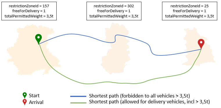
Restricted road section 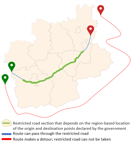
|
| PTV_SpeedPatterns |
This layer provides statistical and time dependent absolute speeds for a given set of road segments, that can be used by route
calculation instead of the NC/SC speed defined by the vehicle profile As soon as real-time Dynamic Traffic Information is available as an additional Feature Layer, it can be combined with the historic traffic patterns. The combination of forecasted and actual traffic information result in a more precise view of the near future, for example road works in combination with a traffic jam as the result of an accident. Optional: The speed patterns can be adapted to specialized vehicle types like trucks, for example. |
Routing with historical traffic data. |
| PTV_TimeZones - time zone information |
This layer provides time zone information at a given location. This information is necessary to consider time dependent restrictions correctly in the route planning, for example temporary road closures and road works. Different time zones can be considered in routing and estimated time of arrival calculation. Time zones can be precisely displayed, especially in connection with historical traffic information and traffic patterns. Time zone information will not be rendered at all. But it is always available for all other Feature Layers, which need access for it, so it never has to be enabled explicitly in the requests. |
Output of the correct local ETA |
| PTV_TruckAttributes |
This layer provides truck-specific driving restrictions. These features concern the dimension, the weight or the type of the vehicle. This could be important for the clearance height of tunnels or the weight restriction of bridges. This Feature Layer is fairly often combined with time dependent restrictions. So, the features are only valid during a certain period of time. The truck attributes are considered in the routing or in distance matrix calculation. Therefore you gain more accuracy and a better planning basis. Truck attributes can be displayed on segment basis or as icons. |
Routing with restriction data specialized for trucks. |
| PTV_LowEmissionZones |
This layer contains driving restrictions related to low emission zones that prohibit access to the most polluting vehicles. Entering a zone can only be done under specific conditions. Depending on the country, the criteria are different. Some countries use an emission sticker. If the vehicle has the correct sticker, it can enter the zone. Other countries use the EURO emission level property. Vehicles below a certain EU norm are not allowed to enter the low emission zone. |
Environmentally conscious routing. |
Dynamic Feature Layers
| Layer | Description | Use Cases |
|---|---|---|
| PTV_TrafficIncidents |
This Feature Layer provides real time or forecasted traffic events, such as traffic jams, construction sites or temporary road closures. Traffic events are considered in route calculations and can be displayed, similar to PTV_TruckAttributes, on segment basis or as icons. Two providers ("tomtom", "ptv") are available to configure the content update service. PTV also maintains some traffic incidents in selected countries, for example long term truck incidents. |
Routing with real-time traffic, e.g. for calculation of estimated time of arrival. |
Custom Feature Layers
| Layer | Description | Use Cases |
|---|---|---|
| PTV_RoadAttributes |
Users can design their own custom Feature Layers by selecting road segments to access data and by defining their own Feature Layer Attributes as described in PTV_RoadAttributes. |
Routing with user-defined restrictions. |
Related Topics
| Technical Concept | GDF time domains |
| Technical Concept | Feature Layer attributes |
| Technical Concept | Custom Feature Layers |