Characteristic
Short description
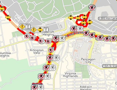
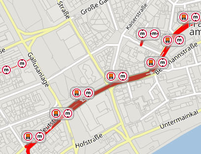
Feature Layer Rendering is the process of visualizing important road attributes on the map.
Use
The route![]() A route corresponds to a path of a vehicle through the underlying transport network. The main attributes of a route are the distance and the time that the vehicle travels along the path. calculation in combination with additional road attributes of Feature Layer may result
in an incomprehensible outcome, quite often caused by the large amount of Feature Layer data.
To make the routing more traceable, the Feature Layer attributes can be shown in a map.
A route corresponds to a path of a vehicle through the underlying transport network. The main attributes of a route are the distance and the time that the vehicle travels along the path. calculation in combination with additional road attributes of Feature Layer may result
in an incomprehensible outcome, quite often caused by the large amount of Feature Layer data.
To make the routing more traceable, the Feature Layer attributes can be shown in a map.
Detailed Consideration
Feature Layer Data
Additional Feature Layer data can not only be used by the PTV xRoute service in route calculation, but it is also possible to visualize this additional data via PTV xMap service on the map. To emphasize the calculated routing result by visualizing the relevant information on the map, the technology allows the definition of different individual and configurable rendering styles for each Feature Layer theme. Defining country dependent styles and filters are also possible.
Examples
Good to know
Combinability of Themes
As for the routing use case these themes can be combined, individually selected and prioritized. By means of client-side requests it can be defined which layers are to be visualized on the map.
Style and Filters
The style and filters of visualization can be adapted according to your wishes by modifying the accompanying XML files. Defining country dependent styles and filters are also possible.
Geometries
Feature Layer attributes can be rendered as strokes (configured with color and width), icons or polygons (configures with color, fill and contour), depending on the theme.
Feature Layers icons rendering on client side
Feature layer icons can be rendered on client side.
Related Topics
| Technical Concept | Feature Layer basics |
| Technical Concept | Feature Layer attributes |
| Integration Sample | Interacting with Feature Layer Attributes |
| Showcase | Render Feature Layer Icons On Client Side. |