Characteristic
Short description | Travel speed
Depending on the available data the travel speed for a network segment will be determined in different ways: by default the speed is determined from the basic map data and profile![]() A profile is a collection of parameters used to configure the request. Full profiles consist of a number of specialized sub-profiles like the VehicleProfile which describes the properties of a vehicle. parameters, but may be overridden by Feature Layer speeds.
A profile is a collection of parameters used to configure the request. Full profiles consist of a number of specialized sub-profiles like the VehicleProfile which describes the properties of a vehicle. parameters, but may be overridden by Feature Layer speeds.
Short description | Travel time
The travel time of a network segment is calculated by dividing the distance in [m] by the travel speed in [m/s]. The route travel time is the sum of the travel times for all segments on the route![]() A route corresponds to a path of a vehicle through the underlying transport network. The main attributes of a route are the distance and the time that the vehicle travels along the path.. The travel times are provided with the accuracy of up to three decimal places. To avoid rounding errors it is advisable to always calculate the sum of individual travel times with the maximum accuracy.
A route corresponds to a path of a vehicle through the underlying transport network. The main attributes of a route are the distance and the time that the vehicle travels along the path.. The travel times are provided with the accuracy of up to three decimal places. To avoid rounding errors it is advisable to always calculate the sum of individual travel times with the maximum accuracy.
Use
By default, the network and the speed classes of the map data are used together with parameters of the vehicle profile for the speed calculation.
Detailed Consideration
Network vs. speed class
The map data comprises a network class![]() A network class is an indicator of importance within the road segment sectioning. The road segments are divided into eight network classes by importance of the roads they represent. The network class 0 represents the most important roads, for example highways, while road segments of network class 7 are the least important roads, for example pedestrian paths. The term network level is often used synonymously, in fact the network level equals the network class plus one. and a speed class for each segment. The network class indicates the importance of a network segment. There are eight network class levels (e.g. 0 for highways and 7 for pedestrian paths). The speed class depends on the network class and additional information such as speed restrictions or maximum speeds on different roads (highway, trunk road, rural road, city road). Roads of the same network type may have different maximum speeds, e.g. for wide or narrow, steep or even roads, mostly empty or congested roads, roads with or without many traffic lights, and so on. The actual mapping from network- and speed class to the speed used for the calculation of the travel speed is performed dependent on the vehicle
A network class is an indicator of importance within the road segment sectioning. The road segments are divided into eight network classes by importance of the roads they represent. The network class 0 represents the most important roads, for example highways, while road segments of network class 7 are the least important roads, for example pedestrian paths. The term network level is often used synonymously, in fact the network level equals the network class plus one. and a speed class for each segment. The network class indicates the importance of a network segment. There are eight network class levels (e.g. 0 for highways and 7 for pedestrian paths). The speed class depends on the network class and additional information such as speed restrictions or maximum speeds on different roads (highway, trunk road, rural road, city road). Roads of the same network type may have different maximum speeds, e.g. for wide or narrow, steep or even roads, mostly empty or congested roads, roads with or without many traffic lights, and so on. The actual mapping from network- and speed class to the speed used for the calculation of the travel speed is performed dependent on the vehicle![]() The term vehicle describes what is being routed or planned for. Vehicles are used in route calculation, distance matrix calculation and effectively also in tour planning. In route calculation, vehicle properties like overall size, weight and speed are in focus. In tour planning, it is vehicle properties like capacity and availability.
Commonly a vehicle is motorized, like a truck - including its trailer or a car. However also a bike or even a pedestrian are included in this definition. type.
The term vehicle describes what is being routed or planned for. Vehicles are used in route calculation, distance matrix calculation and effectively also in tour planning. In route calculation, vehicle properties like overall size, weight and speed are in focus. In tour planning, it is vehicle properties like capacity and availability.
Commonly a vehicle is motorized, like a truck - including its trailer or a car. However also a bike or even a pedestrian are included in this definition. type.
Speed profile parameters
Users may influence this mapping through the type Speeds in the vehicle profile. It contains parameters that are used together with the network class and speed class of the network segment to define the actual speed. Minimum and maximum speeds are provided in speedRangesByNetworkClass for each network class.
{
				"speeds": {
				"speedRangesByNetworkClass" : {
				"maximumSpeeds" : [80, 65, 55, 45, 40, 30, 30, 30],
				"minimumSpeeds" : [55, 30, 23, 20, 18, 15, 15, 15]
				},
				"maximumSpeed": 75
		}
Those speed intervals are mapped to the speed classes, as shown in the diagram below. The mapping is performed by a linear interpolation. In addition to the speedRangesByNetworkClass the speed node also contains a maximumSpeed which defines the absolute maximum speed in [km/h] for all road segments.
The graph below describes the relationship between speed class, actual speed and the configured maximum speed for a single network class.
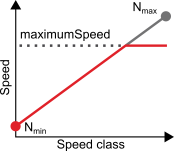
Nmin and Nmax correspond to the minimum and maximum speed configured for the network class. While these speeds are usually reached at the lowest or respectively highest speed class they both are limited by the configured maximum speed. In the graph above this results in Nmax for the network class not being reached even on the highest speed class.
Good to know
Feature Layer speed
In certain Feature Layer themes, for example PTV_SpeedPatterns or PTV_TrafficIncidents, additional speed data is available for road segments. These speed data are usually time dependent: the speed is different depending on the time the segment is passed. If such a theme is enabled and speed data are available for a segment at the point in time the segment is passed, the Feature Layer speed overrides the default travel speed described above.
Also for the Feature Layer speed the profile field maximumSpeed is applied and higher speeds are truncated.
Due to the time dependency it is possible that the Feature Layer speed changes when the segment is passed and two different speeds are used to compute the travel time of the segment. In this case the travel speed that is returned for the segment is calculated as distance divided by travel time.
Long-duration blocking traffic incidents
Feature Layer PTV_TrafficIncidents contains roads which are blocked during several days, weeks or months, due to construction works for example.
The normal behaviour will avoid such roads, by proposing a detour. But, if a waypoint![]() A waypoint is a geographic location used to specify start, destination and possible stopovers for a route. is located on such road, it could not be avoided.
A waypoint is a geographic location used to specify start, destination and possible stopovers for a route. is located on such road, it could not be avoided.
In order to return a result, a route passing through the blocking segments will be proposed, and the speed of the vehicle on these segments is adjusted to 1 km/h.
Moreover, if the blocking still exists when arriving at the end of the restricted area, a violation is applied on these segments.
Related Topics
| Technical Concept | Route Selection |
| Integration Sample | Calculating the best route for rush hour traffic |